Goldilocks and the three bears. The Revenant. These are the things replaying in my head, on loop, followed by scenarios of how I’ll negotiate a grizzly. Which way I’ll run in this narrow wooded section. Perhaps let the heavy bike fall onto me for some protection from the gnashing of claws. How close will I let the bear get, before pulling the trigger on the bear spray. These are the things that run around your head when you’re in bear country for the first time. It’s not a peaceful state of mind, that is for sure. So ‘bear’ with me as I travel down the Grizzly Highway through the stunningly misty Alberta and British Colombia, Canada.
Day 1. Bon voyage
Distance: 23.6mi / Elevation: 2,574ft / Finish: Spray Lakes, AB
Full ride data on Strava: https://www.strava.com/activities/582651998
I’m all set and ready to leave Banff. I hear someone holler out… “Yewwwwwwwwww!” from just up ahead. It’s Crazy Larry! I’ve heard of this person, he is very passionate about the Tour Divide, which follows the trail of the Great Divide Mountain Bike Route. Larry rides the lead out each year for the Tour Divide MTB race. I’m just about to get off the street and into the forest to the start of the trail when I met him. The Tour Divide starts June 10 for 2016, he also runs an info night for riders. We have a short chat about why I’m here, snowpack levels, exchange details and I’m off. As I pedal I’m running through my head if I’ve forgotten anything, pretty standard when your leaving for a trip! I think the only thing I’m not super knowledgable on, is bears. I researched the methods of setting up a modern bear bag last night and got the gear for this in town, plus bear spray which I’ve mounted to my handlebars for quick access. The first day riding is nice easy undulating terrain, as I make my way to Spray Lakes, BC with a killer view of the surrounding mountains.


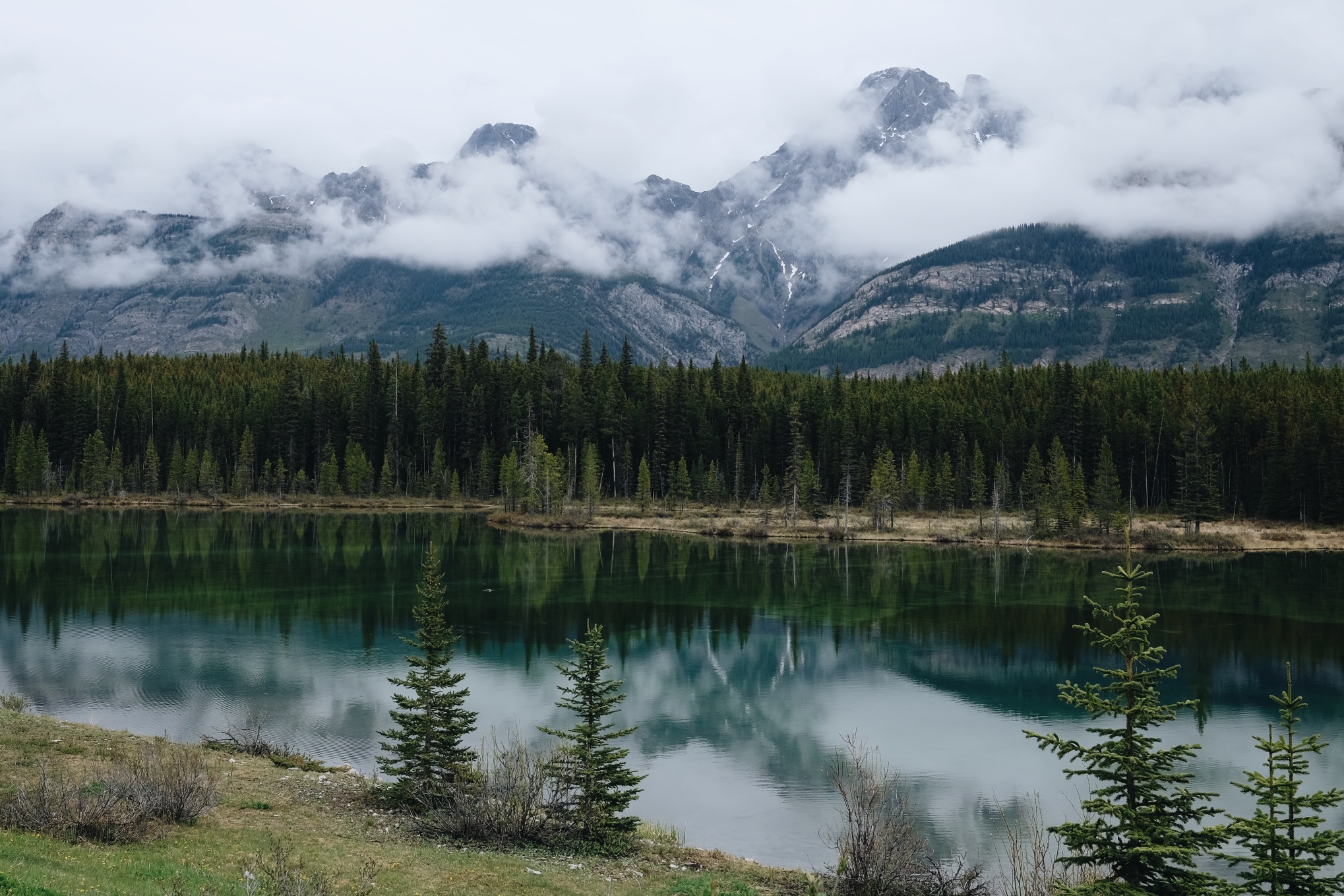
Unfortunately for me, Mother Nature decides dinner time is also the best time for a rainstorm. Rain sets in which after some times turns to drizzle. Which is how I can express my time in Canada. On the lookout for grizzly and super drizzly. For now, here is one fine weather image 🙂

Day 2. Rain
Distance: 33.2mi / Elevation: 2,297ft / Finish: Canyon Creek, AB
Full ride data on Strava: https://www.strava.com/activities/582652061
I completely failed to find a secure a branch to hoist all the things (food) that may attract bears up on last night. The trees in this area are mainly trunk with fine branches, easily broken I discover. So I stashed my food about 60 meters downwind, under some rocks near the water in a dry bag. With all the rain I figure it’s going to be hard for a bear to pick up a scent. Thankfully, all was well in the morning.
I didn’t sleep particularly well, just too alert, paranoid, about bears. I get up late and repack things a little better on the bike, I also mount the bear spray to the bars for quick access, remembering a story the shop assistant told me yesterday about a biker having the bear spray in their backpack and not being able to get to it, yikes. Rain interrupts final packing and I set off in a drizzle which sets the tone for the day as I ride amongst foggy mountains, lakes and streams yelling Coooooooeeeeeee (it’s an Aussie thing), every 5 minutes to alert all carnivores of my impending presence.

I spot two lots of bear scat, but I’m not actually sure what it looks like. Later in the day, there are quite a lot of bear prints on the road to Canyon Campsite. I get a rear flat after midday, luckily on an uphill, it’s a shard of glass and has made a small cut in the tyre, I repair the flat, but will keep on eye on the cut in the tyre. I had planned to get new tyres en route, this will expedite that need.


Canyon Camp is nice, toilets, bear bins for trash which have a clever latch system. No bear safe food storage though. I struggle with my bear bag again and finally get it hoisted this time. It’s really not high enough but it’s the best I can do today. Also, it’s freezing out! There is a visitor centre near the camp and posted on the notice board is the forecast. The next four days are wet and getting colder 0-9c. Tomorrow is the first mountain pass I’ll ride. I was at 1800m elevation today on a small climb, I walked much of it, as I don’t have the stamina yet. It will come. No point hitting things hard, maybe in 3-4 weeks. Time to watch an episode of Fargo and churn through some audiobooks in the tent while it continues to drizzle out. Sunset is super late here, need entertainment when there is nobody else about at Camp.
DAY 3. Bears, deer and free beer
Distance: 56.0mi / Elevation: 3,375ft / Finish: Elkford, BC
Full ride data on Strava: https://www.strava.com/activities/582652084
Left camp this morning to find a better camp with hot showers and toilets nearby at Elk Lakes, haha. Warmed my hands in the heated washrooms and kept pushing. Elk pass had a bit of snow in places, some melting beside the trail, leaving a muddy affair for myself to contend with. I made my way down the pass to a cabin and picnic table, screaming Coooooooeeeeeee all the way, letting the Bears know an Aussie is coming. From the pass descent to this cabin I count as many as eight separate bear tracks on the way, with a cub part of the brigade. I continue on to where I thought I might camp to have another feed and decided I didn’t want to spend the night here, beside the bear highway and pushed on to Elkford, on a slippery sloppy muddy road arriving in town with a kg or two of mud and gravel attached to the bike. Campsite facilities were excellent, hot showers and heated washroom building meant I could dry out some things. I made my usual dinner and was still super hungry, after a a visit to a very well equipped supermarket I came back with a huge tub of hommus and pack of chips and ate the lot! So good!

Sitting in the endless drizzle gets tiring, so I head to the pub across the road and spend the night swapping stories with the locals and being unable to pay for my own beer, it’s the Canadian way apparently, it was also Tims birthday, local lad working the mines here, so we all had Tequila shots to celebrate his 20th. Still drizzling outside when I get back to the tent after a lift from the Pub with Chuck, Chuck picks up a lot of cyclists along the route if they have any troubles, he runs a cabin on the road out of Elk pass into Elkford. Good to hear there is help along the way for fellow cyclists if they find trouble. Thanks buddy, what a legend!
Day 4. Drizzle for shizzle
Distance: 29.4mi / Elevation: 1,882ft / Finish: Sparwood, BC
Full ride data on Strava: https://www.strava.com/activities/583605156
I sleep in, make a meal in the cold wet outdoors and then roll on down to the next town, Sparwood, via some bush bashing and then onto the lovely lower Elk Valley Road into Sparwood, known for its really big truck (worlds biggest?) there is probably more pictures of this truck than selfies on Instagram, It is a little surprising that such significant mining is happening right beside such stunning landscape. Today is pretty uneventful, just trying to keep dry!
Day 5. Zero!
Drizzle continues, I decide to stay another day at Sparwood and look into the next section, three days in wilderness, the flathead valley with three mountain passes and a river crossing that usually requires bicycle dismantling. The afternoon is spent at the Sparwood Pub, the only place that’s warm and out of the rain!
Day 6. Plan B
Distance: 33.9mi / Elevation: 790ft / Finish: Fernie, BC
Full ride data on Strava: https://www.strava.com/activities/585805856
D-day for hitting flathead pass. I’m off to the supermarket to stock up but I’m overwhelmed with much hesitation, I’m only a few days into this trip and the weather is not desirable at all to do the next three days with more rain and snow at elevation. I’m riding solo and the temp forecast with rain just reads imminent disaster to me. So, I decide to take a b-line along the old great divide route to Fernie, after remembering I had left something behind. Doubling back and getting another rear flat tyre… What is going on with these rear flats? I finally make it into Fernie and have a hot meal at The Lunch Box and hit the Raging Elk Hostel to dry out and research this new route I’m taking over the border. Until 2010, The Great Divide Mountain Bike Route followed this path.

Day 7. G’Day USA
Distance: 67.9mi / Elevation: 3,352ft / Finish: Eureka, MT
Full ride data on Strava: https://www.strava.com/activities/587114351
Today ended up being a double distance day as I missed the first camping option and was feeling energetic so kept pushing into the USA for Eureka, MT.


In hindsight, it would have been nice finding that first campsite, but hey, in town I’m camping beside the river which has lush green grass and the sun is shining. It makes for a pleasant afternoon in Montana, USA. My first evening without a rainstorm and drizzle! It’s nice to be out of the tent this time of day for a change. I pick up some local craft beers brewed just south of here at Whitefish. They are super delicious! I was offered a place to crash by a curious woman at the supermarket, her and her partner used to host cyclists often, I turn it down, I don’t know why, it would have been nice to have company, delirious from the big day I guess, I guess don’t want someone to go to extra effort because they feel sad I’m camping outside 🙂 it’s nice to camp outside in fine weather. I decide that I will say yes next time someone asks, simply for the opportunity to mention why I’m riding 2700 miles south, which is what this is all about, raising awareness for early-onset dementia.

Well, that’s the Canadian section done! Again, here is the link to the everyday hero page, where you can learn more about Early on-set Dementia https://give.everydayhero.com/au/mental-for-miles.
I’ll leave you with a teaser of what’s to come in Montana, USA.
